Monday, November 16, 2009

Snowshoeing to Whispering Pines Yurt


Snowshoeing to Whispering Pines Yurt
January 2008 

In January I took my team from work snowshoeing into the Whispering Pines Yurt. For everyone this was the first time snowshoeing and staying at a yurt. The yurt are rented from the Idaho State Parks and come equipted with everything you need. The only thing you need to bring is food and a sleeping bag. We spent the day hiking around the mountain and spent the night eating and playing games.

The Whispering Pines yurt is located off the groomed Gold Fork Loop trail in the Payette National forest. This is a popular loop used by Nordic skiers and snowshoers. The yurt provides easy access to over 27 miles of groomed and 50 miles of marked ski trails. The yurt is located in a high shaded glen. The view from the yurt is one of pine tree covered ridges. The outhouse has a great view of Pilot Peak.

Tuesday, November 10, 2009

Kayaking Lake Powell


KAYAKING
LAKE POWELL
May 2009

Lake Powell is located in Glen Canyon National Recreation Area and was created by the building of the Glen Canyon Dam. Lake Powell is and excellent location for sea kayaking because the many narrow canyons and spectacular alcoves. We launched our kayaks at Bullfrog Marina and paddled 10 mile north up the reservoir and made a base camp. From there we day paddled many of the canyons one of which was Forgotten Canyon where we hiked up to Defiance House which are Anasazi Indian ruins built into the cliffs. We were on constant watch for storms that often form in the afternoon. One day we had just made it back to camp when a storm hit and was blowing hard enough to blow our tents flat. On our way home we visited Capital Reef and Zion National Park.


Monday, November 9, 2009

Kayaking Snake River


KAYAKING

SNAKE RIVER

October 2007

The South Fork of the Snake is in southeastern Idaho close to the Wyoming border. The South Fork begins as it flows out of 20 mile long Palisades Reservoir in the community of Swan Valley, forming a 64-mile stretch of legendary tail-water fly-fishing, it has been rated as the best wild trout fishery in the lower 48 states.The South Fork is also a beautiful river for flat water rafting, canoeing and kayaking.
My son Troy and I put in at Swan Valley Idaho and paddle about 5 miles and made camp for the night. The next morning we woke up with several deer in our camp and figured they were hiding from the hunters. We then paddled the canyon section of the river which is a remote stretch that borders the Targee National Forest. We passed several fisherman in drift boats and caterafts and all were catching trout. We took out about 2pm at the boat ramps in Ririe Idaho. In October the weather was a little cold but had fabulous Fall colors.

Kayaking Ross Lake


KAYAKING
ROSS LAKE
SEPTEMBER 2007


Ross Lake was created by the damming of the Skagit River and is in the recreation area of the North Cascades National Park. The elevation of the lake is 1600 feet and it is over 20 miles long. The climate is similar to Seattle's.

We started by putting in on Diablo Lake and paddled 3 miles to the base of the Ross Lake dam. At the base of the dam is a phone for you to call for a truck that shuttles us and our boats up to Ross Lake.

We then put in on Ross Lake and spent 4 days paddling to the north end of the lake which is in Canada. along the way there were several side canyon we paddled up and found water falls at the end of the them.

At the end of the lake we were picked up by a shuttle boat and brought back to the dam and did the process in reverse.

Sunday, November 8, 2009

Sea Kayaking Channel Islands


SEA KAYAKING
CHANNEL ISLANDS
SEPTEMBER 2006

In September of 2006 my friend Bruce and I drove to Ventura California and boarded a shuttle boat to Santa Cruz Island in the Channel Islands for a week of kayaking, snorkeling and hiking.
California's Channel Islands, located just off the coast of Santa Barbara and Ventura, are a National Park dream-come-true for marine nature lovers. The crystal clear Pacific channel waters, many mysterious and eerie sea caves, breathtaking cliffs, abundant wildlife, and mild weather combine to lure expert kayakers and novices alike to explore their natural wonders. Each encounter with the caves, tunnels, arches, grottos, and blow holes is a unique blend of sights and sounds created by submarine fissures and openings, and the contorted volcanic island formations. And the sheltered paddling areas very often are without surf or strong winds.

Climbing Mount St. Helens


MOUNT ST. HELENS

APRIL 2001


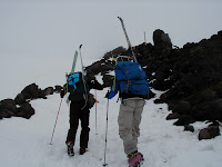
April 2001 climbed Mount St. Helens with my friend Steve. Day one we hauled our get by sled to the end of the tree line and made camp. The next day we left camp at 8am and summited at 2pm. I went to the rim and was looking into the crater when I noticed all the foot prints stopped about 10 feet back from the edge. I them realized I was standing on a cornice hanging a 1000 feet above the crater floor. My goal was to then ski down the mountain back to our base camp but the snow was so hard and icy I did what everyone else was doing and slid down the mountain on my butt.

[ Photo ] USGS and Forest Service Scientists stand at the rim of Mount St. Helens during an August 2005 research trip.  In the distance is Mt. Adams..


Mount St. Helens is an active volcano in southwest Washington State and the central feature of the Mount St. Helens National Volcanic Monument.

We climbed using the Monitor Ridge Route from our Bivouac. This route gains 4,500 feet in five miles to the crater rim at 8,365 feet elevation. Although strenuous, this non-technical climb does require one to be in good physical condition.